Category Archives: California

Odesza at the Shrine Auditorium & Expo Hall

IMG_8973Odesza is one of my favorite electronic music groups so when I saw that they were coming to Los Angeles and I had a chance to see them at the Shrine Auditorium & Expo Hall I couldn’t resist. I bought the tickets as soon as they went on sale and then patiently waited months as the time passed. While I waited I listened to their beats on Youtube and Songza constantly feeling inspired by the rhythm of their music.

Katie and I arrived at the theater early, waited in line, and quickly made our way to the entrance. We were searched with metal detectors and then allowed into the auditorium where we made our way to what looked like a huge basketball court. There was an upper balcony level for VIP.

I had never been to a concert quite like this before. You could say it was like a mini rave. It was obvious that people were drinking as they had booths set up on the edges of the floor, but I’m sure others were also smoking weed as the smell of it lofted through the air around them.

As the DJ spun to get everyone into the mood we explored the merchandise booth and bought a really cool sweatshirt. Then we headed to the floor and tried to see how close we could get. The DJ was followed by some singer, I’m not sure who he was, but he was ok and we continued to move closer as the time got closer and closer to when Odesza would be on stage. Eventually, we stopped moving forward in the crowd when we were only about 5 rows of people back. From that point on it was a mind set to hold our ground as people tried to scurry and weave around us to get closer.

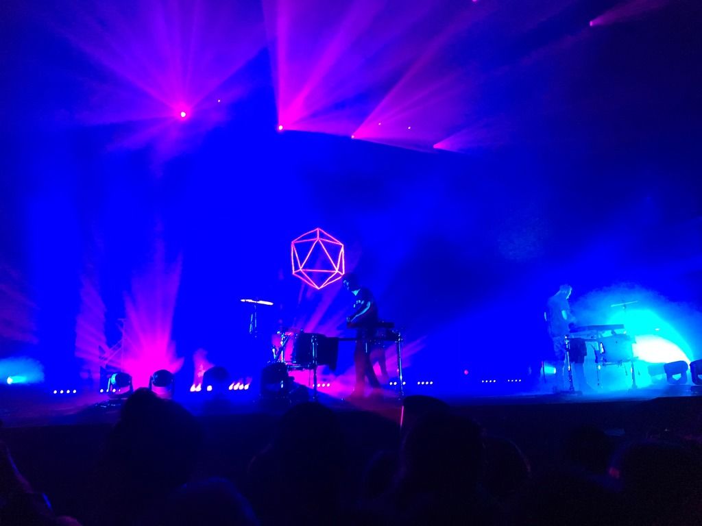
Once Odesza came on stage everything seemed to settle as everyone drifted off into the musical hypnosis. They played an entire set with a huge screen behind them playing videos and intricate designs behind them. Two of my absolute favorite songs were played that night, Memories That You Call (feat. Monsoonsiren) and Say My Name (feat. Zyra). When they played them I was in heaven, melting into the music as it streamed through my ears and into my entire body.

They wrapped up their set with fireworks sparkling upon them and then everything went black. The audience’s constant cheering encouraged them back to the stage for an encore. Where they played a few more songs and ended things with streamers falling from the ceiling’s rafters.

The concert ended pretty late and with our ears ringing we made our way back to the car. The experience was supreme and if you like electronic music Odesza is a group that you should be sure to see at least once.

The Elephant Trees Trail of Anza-Borrego Desert State Park

IMG_8973On our drive leaving Fish Creek’s wind caves Katie and I found another small trail, the Elephant Trees Trail off Split Mountain Road. There was still some light in the sky and we weren’t quite ready to leave the Anza-Borrego Desert State Park so we decided to see what the 1 mile nature trail was all about.

We turned off Split Mountain Road and quickly bounced down the 1 mile dirt and rock filled road to the trailhead. I believe a high clearance vehicle is best, but a lower vehicle could possibly make it if you went slowly. On the day we were there we had only seen 2 other cars in the park so we knew we wouldn’t run into any other cars leaving the trail. Good thing because the road is only about the size of one vehicle, very narrow, and is lined by stones to prevent vehicles from driving off the path.

After our short laughter full jaunt down the road we parked the truck right by the entrance to the trail. The same stones outlined the round-about at the end of the road as there really is no parking lot. We grabbed our packs and a nature trail pamphlet from the trailhead and started off on our self-guided nature walk.

There is basically no shade on the trail, not a problem if you go later in the day before the sunsets, but if you plan to go mid-day in summer be sure to bring your hat, sunglasses, sunscreen and some loose light clothing. The trail is very easy and is great for people of all ages. It is clearly marked and easy to follow with only a couple questionable spots that can be distinguished if you just keep moving a little farther down the path.

The  first stop is to welcome you to the trail. The following couple are very close together and include a catclaw plant, a creosote bush, and a desert lavender plant. You learn a little about each plant at each stop.

IMG_8971       IMG_8971

IMG_8971       IMG_8971

The trail tends to get farther and farther between each point as you continue. An indigo bush which developed light-colored bark to reflect the sun’s rays, a brittle bush which leaves brittle stalks behind after producing bright yellow flowers, and an ocotillo which drops its leaves and grows new ones up to seven times in a year. After reading about each plant’s flowers and leaves I can only imagine what it would look like in the flower blooming season, February thru April.

IMG_8971       IMG_8971

The smoke tree was the next to see along the trail. Apparently their seeds need a flash flood before they will sprout in the newly moist sand to grow into seedlings with big green leaves.

Number 9 is the plant the trail is named for. The Anza-Borrego  Desert is the only place in California that the elephant tree grows. We finally reached the only one along the path with its trunk that stores water and its gummy sap that bleeds when it is injured.

The desert trail ended with barrel, fishhook, prickly pear, and cholla cacti. This last stretch is your chance to observe all the different cacti and see if you can locate a few plants that were pointed out along the trail. The desert is an amazing place with plants that have adapted to the conditions around them.

IMG_8971       IMG_8971

With one final look at the desert trail we headed back to the truck as the sun set behind the mountains of Fish Creek. The sky lit up on fire as streaks of red, pink, purples, and blues colored it just above the horizon. I absolutely love desert sunsets in Anza-Borrego. They are something that everyone should see at least once in their lives.

Off Road 2-Wheel Driving to Fish Creek’s Wind Caves

IMG_8973The weekend at Anza-Borrego Desert State Park was one of the best and most fun weekends ever. Ranger Don at the Arroyo Tapiado mud caves was one of the reasons it was so much fun but my visit to Fish Creek’s wind caves were also a major part of it. If you ever head to the Anza-Borrego Desert State Park be sure to visit Fish Creek. You won’t be disappointed.

After much discussion with the Ranger Station, the Visitor Center, and Ranger Don the reviews were mixed. One ranger from the station had said we would be fine with our 2×4 high clearance truck, while the visitor center could only advise us that we needed a 4×4. Ranger Don seemed confident that we wouldn’t run into any trouble, but then a completely different ranger at the station would tell us she couldn’t advise us on Fish Creek conditions because it was not her section of the park. Finally Katie and I decided to head over to the dirt road that leads out to Fish Creek and make an educated decision as to whether we thought our truck could make it or not once we got there.

We drove east on Route 78 and then south down Split Mountain Road until we arrived at the dirt road. We immediately knew we would head out to the Fish Creek Campground. The road centered in a sandy wash was an easy 1.5 miles of packed sand due to the rain storm of a previous weekend. It was so easy we almost completely missed the campground, barely noticing the small sign to our left quickly continuing to the narrow passage between Fish Creek Mountain and Vallecito Mountain. As we rounded the corner and came to the iconic raise fossil reef we stopped the car to take a look at our first section of tricky large rocks. We chose our route, a slight bare to the right and a hard left and we were through. We stopped several times along that section of the route to make sure we were picking the best path to drive. We wanted to make sure no large rocks would sneak up on us and any loose sand was avoided.

30 minutes later we finally arrived at a large fork in the road. To our left was a tiny sign that read, “wind caves” the start of the trail. We were the only ones there so we parked near the entrance, packed our camel packs, put on our sunscreen, and started up the rugged path.

The trail is relatively short, about 1.2 miles total, with an incline to begin that gradually levels out. Eventually you reach a small rock where the path splits. Either way will bring you to the wind caves the question only is do you want to start at the bottom or the top of them. We chose the left path and were brought to the top.

I have to say the wind caves are amazing. They are so much fun to crawl around inside, through, and over. Many of them are large enough to stand up straight and tall inside. They reminded me of where the Flintstones would have lived. The caves are made as the wind whips through and around the sandstone wearing it away over time.

If you climb on top and look under your feet you can see lines and grooves where the sand is wearing away. If you look up and across the creek you have this unbelievable desert view of the Carrizo Badlands. You can see the road you drove in on and miles and miles of sand mounds. If you look closely you might even be able to see the imaginary eyes and nose of a person on the mountain side.

I have to say that out of all the places I’ve been the Anza-Borrego Desert State Park has been one of my all time favorites. Once you reach the wind caves it is so quiet and peaceful. Maybe it’s different on a weekend, but our Monday in December was perfect. All we could hear was the wind and birds for miles. We could have stayed there all day, however, knowing our trek back to the main road wasn’t going to be easy we left with enough time to reach the paved road before the sun set.

Borrego Palm Canyon’s Panoramic Overlook Trail

IMG_8973After Katie and my fun day with Ranger Don in the Arroyo Tapiado mud caves we headed over the the Anza-Borrego Desert State Park’s Visitor Center to ask about the road conditions in Split Mountain for our plans for the next day. Two days prior I heard that it was do-able in a 2×4 truck, but every day after that everyone kept telling me we needed a 4×4 vehicle. While we were there we decided to take a walk to a short trail out of Borrego Palm Canyon Campground, the Panoramic Overlook Trail.

From the parking lot of the Visitor Center in Borrego Springs we hiked .5 miles along the paved path to the Borrego Palm Canyon Campground. It’s kind of cool and has the planets in our solar system placed along the way so you can somewhat see how far apart they all are in terms of a .5 mile.  Once at Borrego Palm Canyon Campground we quickly turned to the left and easily found the start of the Panoramic Overlook Trail, a one mile hike with great views of the Borrego Valley.

The first part of the hike is through the desert valley floor with small shrubs a desert plants along the pathway. Though I tend to feel as though most desert hiking is a little confusing, this trail is pretty straightforward. Basically, just keep walking straight through the sandy ground.

After a short walk you come to a trail marker at the base of a hill. Yep, you guessed it, Panoramic Overlook Trail goes up to the top of that hill. In order to get great views you usually have to be up high overlooking something below. The trail narrows to one person wide and zig zags in small switchbacks all the way up to the top. Take a moment to check out the way the hill was formed. It looks like layers of rock that once laid flat have been pushed up to now lie diagonal across the ground. The colors of the rocks are amazing too, from bright red to dark, almost black colorations.

IMG_8971       IMG_8971

IMG_8971       IMG_8971

As you go, stop occasionally to check out the valley below. The view just gets better and better the further you go. The path stops and there is only one choice left, a short climb up through a narrow and almost no existent path. Once there you are at the top. A collection of big black rocks lay there marking the end of the trail. It almost looks like a fist cheering you for making it to the top.

From the top you can see the Borrego Palm Canyon Campground below. It’s dark paved roads stick out like a sore thumb against the mountains that surround the Borrego Palm Canyon Trail. You can also see Borrego Springs, a green thriving town in the middle of a vast brown land scape. If you go in the late afternoon you can watch the sun set on your way back down the hill. I have to say that the sunsets in Borrego Springs are one of the prettiest I’ve ever seen. As the sun falls below the mountains to one side it lights the other mountains across the way with brilliant pinks, oranges, and bright reds that you won’t see anywhere else. Pictures can’t seem capture the true essence of the beauty, but I still try every time.

We headed down to the valley floor before the sun had begun to set, but once you are done taking in the view head back down the hill the way you came up. Finding the route you came up on is probably the trickiest part of the whole short hike. It seems like no matter which way you choose you are setting yourself up to fall off the mountain, but once you find it again you will see the narrow path and be able to follow it back down. Once you reach the bottom head back the same desert trail you followed out. Be careful not to veer off it. Usually there is a rock in the center of the path to tell you not to go those ways.

The Panoramic Overlook Trail is a great walk for people of any age to explore. It’s short, easy and everyone will feel comfortable on this gorgeous hike. The views are bound to having you telling all your friends about it time after time.

Big Burgers at Big Horn Bar & Grill

IMG_8971Our first night in Borrego Springs Katie and I arrived earlier than we had expected, but still late enough for the residence of Borrego Springs to have called it a night. We were hungry so we yelped a nearby restaurant, Big Horn Bar & Grill, which is inside the Palm Canyon Hotel and RV Resort. It had 4.5 stars and was one of the few places still open at 7pm, so we decided to give it a try.

When we walked in we could see a small store to the left and the dinning room ahead. It was completely empty except for 2 guys at a table eating dinner and the workers milling around. We sat at a high top and quickly read through the menu. Our waitress stopped by and took our order, nachos and burgers. We debated getting a drink or two since the prices were so cheap, but decided not to.

A few minutes later our food arrived. The nachos was the first thing we dove into. They had gooey cheese, sour cream, jalapeños, green onions, and chicken. It was amazing. Next I ate my Western Burger with onion rings, bacon, and BBQ sauce and sweet potato fries with maple syrup on them. Katie had her Jalapeño Burger and their regular seasoned fries. Both meals were so surprisingly delicious that there was none leftover.

We left Big Horn Bar & Grill stuffed to the max and extremely happy we had stopped. Next time we are in Borrego Springs we will be going back. Fair prices and big portions on awesome tasting food is always something we welcome.

Giddying Up To Mud Caves with Ranger Don

IMG_8973Katie and I went to the Anza-Borrego Desert State Park just a little under 4 hours away from Los Angeles for a weekend getaway. We arrived late in the evening at my friend’s place in Borrego Springs, super close to everything that we wanted to see. I have to say that I absolutely love the Anza-Borrego Desert. Only having been there once before I couldn’t wait to start exploring the desert again.

The next morning we woke up early and took a quick look at the Anza-Borrego Desert State Park’s Interpretive Activities. We headed out to Mt. Palm Springs Camp Ground to meet with Ranger Don for an Auto Tour to the mud caves of Arroyo Tapiado. Along the way our phones went in and out of service, but the route was very straight forward and clearly marked except for the final camp ground turn off.

Ranger Don was late due to some kids that were digging a trench in order to film a desert scene in their movie, but once he was there he was ready to go and so excited to show us the mud caves and his section of the park. He spoke to us for a few moments letting us know that we could ask him anything about the park or his job or anything related. Then we all jumped in our cars and followed Ranger Don to the dirt road that led to the mud caves.

Since Katie and I were driving her 2×4 truck we opted to stay right behind Ranger Don. He headed out of the camp ground and didn’t waste any time reaching the dirt road that takes us to the Arroyo Tapiado mud caves. He pulled off the road and let everyone else catch up, then headed down the dirt road and out toward the caves. Pretty much every path reconnected with the original path except at one main turn and then once in the canyon there was only one way to go. It was so much fun!

Being that we were keeping right up with Ranger Don and the rest of the group was falling behind, occasionally Ranger Don would stop his jeep and come talk to us while the others caught up. He reminded us that since we didn’t have a 4×4 if we felt like we were gonna get stuck we should just step on the gas and “giddy up through it.” He also pointed out a little campground Hollywood and Vine that we might camp at sometime this winter and the cave where the young man had recently gotten trapped inside and died. Even though it doesn’t seem like it, the mud caves really are very fragile. They might look intriguing, but it is advised not to go exploring these caves as they can collapse at any time making rescue difficult to impossible. It really was an unfortunate event that they were unable to rescue this young man.

Eventually, we reached the main Arroyo Tapiado mud caves. The first mud cave we saw Ranger Don chose not to have us explore inside. It was right beside a plaque that told us all about the caves which are just walls of dried mud. Over centuries water has been sculpting these canyons and caves and rains and flash floods continue to form and change the tunnels today. Ranger Don told us that according to Google there are about 22 mud caves in the area. He took us to a three that he hadn’t explored in a few years.

The first mud cave that we explored had a small opening about 4ft tall to 4ft wide. We ducked under the low ceiling and came out into a tunnel that was pretty tall. As we followed the tunnel the path it became pitch black. Good thing we had borrowed Ranger Don’s flash light or we would not have been able to see anything. The cave become narrow in some sections and wider in others. Some places you had to climb over, duck under or scurry around to continue into the darkness. It seemed to go on and on forever. We eventually decided that the others were waiting for us so we headed back to the beginning of the tunnel.

IMG_8971       IMG_8971

Ranger Don told us that some of the mud caves go straight through the mountains and come out the other side in complete darkness while others end up on the top of the mountains and have openings along the way. It all just depends on which you explore. He took us to the next cave which the entrance had been blocked by a huge chunk of stone that had fallen from above. I squeezed underneath and came to a short pathway that led back into a big open room with a large opening at the top. If it wasn’t just dried mud it would have been a rock climber’s dream. I could only think that when it rained water might run down the wall similar to a waterfall. There was one small tunnel to the side, but the slit was so small no one of our group could fit through it.

IMG_8971       IMG_8971

The last mud cave we explored had extremely high walls and many open ceilings. It was beautiful. We left the group for a moment and followed the path back where dried mud walls would slant across the path and we would dip beneath them for a few moments and soon be in another open section. It was interesting to see how the mud sat in layers within the walls and bubbled in others. Realizing we had been gone for a while we hurried back to the entrance to say our goodbyes to Ranger Don. I got a picture with him and his truck and then we followed him back out to the main road.

IMG_8971       IMG_8971

IMG_8971       IMG_8971

IMG_8971       IMG_8971

I have to say Katie and I had a great time that day and for not having had much desert driving experience Katie did an awesome job driving and following Ranger Don. By the end of our tour we had ear to ear smiles and Ranger Don was a big party of it! I am so grateful that the Rangers at the Anza-Borrego Desert State Park make time for visitors and truly enjoy showing guests around the area.

Swept by Fire at The Corriganville Movie Ranch

IMG_8973Early in November Katie and I headed over to Simi Valley to see Corriganville Movie Ranch. What was once a thriving western movie set in the 1930’s, 40’s, 50’s and 60’s caught fire in the 1970’s, seeing it’s last film crew in 1976. Today Corriganville Movie Ranch is a public park with various concrete and brick foundations as the only remains of a once magnificent set.

Inside the park is a short, .5mile interpretive trail that tells about the different sights along the path. We first came across the remains of a lake which was used in many Western movies and an overhang that looked out into it. You can even see where they would shoot any underwater shots down by what looks like a dried up dam now. The lake is completely dry and looks like there hasn’t been any water for years.

We crossed the bridge that ran over the lake and soon reached a rock that was often used in films as the entrance to the valley. It can be seen in the 1951 movie Jungle Manhunt. Our next stop was at Trail Blazer Cave, seen in Dracula and Billy the Kid. It’s actually a clever fake cave according to the sign. We scurried up looking for the cave, but only found a ver small cave that I’m sure isn’t the one they used in the films. Next time we’ll have to see if we can find the real one.

We continued on and soon came to the remains of the Corriganville Movie Ranch. The town had many different names in Hollywood such as Dodge City, Mineral City, Tombstone, and Lone Ranger Ranch. However, it was known as Silvertown to many visitors. As we read the signs around the edges, I tried to imagine what the set looked like back when film crews were running through the streets. The pictures helped a bit, but the town was really big and with just the foundations left it was hard to tell where the stables, jails, saloons, and banks were. In the 1950’s and 60’s people could visit the ranch on weekends for only one dollar and experience live western music, stagecoach rides, pony rides, and boating on the now dry lake. They could also watch stuntman shows, see movie and TV actors signing autographs and posing for pictures on the real western street movie sets. It’s sad to realize that all of those things will never happen again here due to the fires that ran through the area in the 1970’s.

Corriganville Movie Ranch is a fun short walk and history lesson for people of all ages. Every one will enjoy exploring the area and trying to guess what it used to look like back when the set was being used every day.

Jocko’s Steakhouse

IMG_8971On our way up to Morro Bay Katie and I stopped at Jocko’s Steakhouse in Nipomo, CA one of the best steakhouses in the state. Katie talked and talked about this place before our trip and I have to say, it didn’t disappoint. It actually exceeded my expectations.

We arrived in the early evening with a reservation for 6:45pm. Katie had told me that even though we had a reservation we would be waiting for a while. Often Jocko’s begins to turn away guests in the evening as they get so packed they cannot serve everyone that wishes to eat there. We told them that we were there and waited in the bar drinking beer and shirley temples. We stepped outside for a moment to watch the chef grill as many as what looked like 50 steaks at a time on their huge grill, astonished at how he was able to keep track of them all.

An hour later we were finally seated, thankful that our wait time wasn’t 2 hours like it was for others at the bar we spoke to who hadn’t called first. We ordered the steak to split with two plates. Katie wanted it rare, I wanted it medium, so we settled on medium rare, which turned out to be perfect. Katie took the more rare half and I ate the more cooked half. The meat melted in our mouths and I was so excited to eat it when it arrived that I completely forgot to take pictures.

The fries and beans were less than par, but we really only went there for the steak. So, if you are ever in the area and craving steak, Jocko’s is the place to go. Their meat is the freshest around and best tasting with a salty crust that is delicious.

Spooner’s Cove in Montana De Oro

IMG_8973On our way home from Morro Bay State Park Katie and I stopped by Montana De Oro State Park. It is only about 15 miles south of Morro Bay. With the girls still with us I had found a beach in the park that they were allowed to run around on and enjoy with us, Spooner’s Cove.

Once we finally found Montana De Oro State Park, the campground, and the visitor center or what used to be the Pecho’s family ranch house we headed to the beach just below. We parked in the lot in front of Spooner’s Cove, leashed up the girls, and headed out to check out the beach. Punky was ecstatic. She barked and barked as we trudged through the rough white sand until we reached the water’s edge where she continued to bark until Katie finally picked her up to calm her.

At the water’s edge the sand became coarse rocks, sea glass, and shells about the size of mini chocolate chips. We jumped to the rugged rocks to explore the tidal pools. Slippery with algae we cautiously moved out toward the sea slowly as we looked at bigger and bigger pools. We found fish, snails, and small crabs living within the crevices.

IMG_8971       IMG_8971

It got so slippery that we decided to head back. As I jumped back to the beach my foot sunk deep into the coarse sand and the water rushed into my sneaker. Not discouraged by my now wet shoe we continued to explore, walking along the shoreline in the bay. There were two scuba divers in the water and another man fishing along the shore. The birds were scavenging a fish skeleton and Frankie couldn’t resist charging toward them and sending them flying away. She absolutely loves running along the beach.

We examined the south side of the cove, took some pictures of the interesting rock figurations and formations and explored a bit more. If we didn’t have the girls we might have explored even further, but our time had run out. We needed to get home for a concert. We headed back to the truck with smiles upon all of our faces happy about the day, explorations, and sights we had come across.

Spooner’s Cove is fun for everyone. I can only imagine how much I would enjoy it in the summer. Laying on the beach, swimming in the gentle waves, exploring the rocks and trails along the shoreline, and diving among the fish. Seeing everything the area has to offer was all I could think about while I was there. It seems like a perfect summer vacation spot.

Schnauzers on the Black Hill Trail

IMG_8973While in Morro Bay Katie and I went on a hike with her two dogs, Punky and Frankie. From the campsite we jumped in our truck and headed out of the campground until we realized that the trail was actually right in the Morro Bay State Park. We parked back at our campsite and walked to the end of the campground past the group sites where the trailhead was located.

We reached the trailhead of Black Hill Trail, a 3 mile round trip hike that dogs are allowed to traverse and started our trek across a field surrounded by grass and short scrubs. As we continued the trail crossed a street and then declined for a short time before it narrowed between tall trees. At this point we started to see small red and green leaves all around us so we held Frankie and Punky in close to our sides. Poison oak lay along the edges of the trail for the rest of the hike.

IMG_8971       IMG_8971

The trail started it’s incline, finishing at a total elevation of 600ft, along a dirt path with fences at different points along the way to discourage mountain bikers. Switchbacks then tracked back and forth up the hill side. With each step we took we rose higher and our view of Morro Bay and the surrounding area became better and better.

We came across a small building and just past that came to a medium sized parking lot that could hold about 30 cars. Turns out we could have skipped the whole mile of the trail and drove to about .5 miles from the top. Here, we took a small break for water for the dogs and a few pictures.

IMG_8971       IMG_8971

Then we continued to the top of the hill where the scrubs and trees had disappeared and bright gold rock covered the surface. We scurried up the rocks and took in the final view. We could see the bay to the west and north, the marshland to the south, and even the land and valley filled with trees to the east.

After we had our fill of the view we headed back down the same trail we used to reach the top. It was a much quicker trip as most of it was now down hill. With the two girls at our sides we reached the bottom without any problems well before sunset.

Black Hill Trail is a great place to hike with or without a dog. The trail is well kept and easy to follow. A good trail for people of all ages and levels. Also, while we were there we were pretty secluded. On our 3 mile hike we saw 1 other dog and about 6 other people. If you are ever camping at Morro Bay, Black Hill Trail is a hike with views of the bay that you don’t want to miss.